

On May 18th, 1980, a 5.1 earthquake shook the northwest and turned what once was a 9,677 ft stratovolcano into an 8,363 ft u-shaped crater. It killed 57 people, destroyed hundreds of homes and created millions of dollars in damage. Ouch.
Mount St. Helens is now the home of a beautiful national park, which attracts thousands upon thousands of visitors year-round. She caught our attention by the shear visibility and mystery of her presence on the horizon. We were very eager to get to St. Helens, as we spent hours of research through various websites. We got up early on Thanksgiving, met our two friends, and headed to the beautiful, white-capped mythical mountain.
It was an easy hour and a half drive from Portland, as we twisted and hugged the curvy road along Lake Merwin and Yale Lake. We expected snow at elevation, but didn’t expect the spotty, icy roads from our parking spot, so we were happy we carpooled with the Subaru instead of using our Fiat.
The trailhead we decided to use was the Climber’s Bivouac trail, but unfortunately, the road leading to this trail was closed due to the snow. So instead, we ended up parking at Marble Mtn. Snowpark. That instantly put us out 2 miles out of our way.
Once we were parked and ready to get started, it was around 9:30am and cold as hell. The snow covered trail started up a little switchback overgrown area that opened up to a lava field exposing St. Helens and all of her majestic beauty. The four of us stood in awe as the sun placed a natural halo around her cratered top- It was already worth the trip less than a 10th of a mile in.

After we passed the lava field, we stepped into a thick, christmas forest which is where we spent a lot of the hike. For the most part, it was a fairly moderate up hill hike. There were a lot of steep parts, but they were manageable- even as we hiked through ankle to calf deep snow.

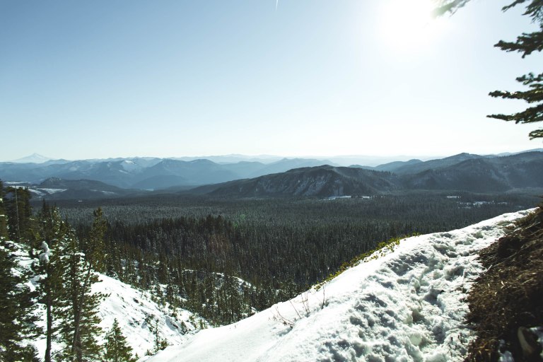
Out of the blue, we exited the thick forest and onto a skinny trail led on a small cliff that hovered over an open valley which presented Mt. Hood standing strong and at full attention, in the far off distance. It was another, “holy crap!” moment and all we could do was stand there as we took in the incredible sight.
We survived the cliff trail and the landscape changed again. Once more, it was covered with trees, but not as dense as the christmas forest. We could feel the timberline getting nearer with each step, even though it still seemed so far away. We would point out the farthest tree and mark that as the timberline, just to find out we still had a long way to go. Eventually, we got to a point of stopping to rest, cook some miso soup, and decided to head back. At no point did we feel defeated. We just felt beyond blessed.

When it’s 1pm, you’ve been on a trail for 3 hours, up hill, in the snow, you know you only have 3 hours of light left. You don’t really have time to pause. Do it anyway. Pause. Find gratitude for the mountains, for your friends, and for your ability to make it as far as you did. It’s an accomplishment to be proud of. Take the time. You deserve it.
Additional boring stuff:
If you’re planning on taking this hike, you’ll need to make sure you have the proper parking pass. Mount St. Helens is a national park, much different than a state park. Also, if you’re planning on summiting, you’ll need a pass for that as well. There are places along the way to St. Helens to pick that up. We knew we weren’t going to be summiting, so we refrained from getting the climbing permit on this trip.

Sounds like a grand adventure in the snow! Good way to spend the holiday. 🙂
LikeLike
It was! I think we found a new tradition…
LikeLike